Vacation Part 2
On Friday we began our trip to see the Morganza Spillway (Levee). We got off to a shaky start on Interstate 12, there was some kind of wreck or something a mile down the road. After crawling along for an hour we decided to get off and go back and get on the back roads. Traveling along the back roads in Louisiana is an education in it self, especially with Bob & Harold being the tour guides. Oh yea I forgot, we were traveling with Bob & Martha Ann and Harold & Dixie Armstrong. Harold is my adopted brother-in -law and my "political adviser"! We have known them for years and just love being with them, never a dull moment.


Our first stop was for dinner, as the picture shows you, it was a quaint place (that's putting it lightly) and the food was just great (when we finally got it). The name as you can see was "Not Your Mama's Cafe". After our food arrived Harold said the blessing for the food, I must say it put us in the right frame of mind. (can't tell you why). The funniest thing was I guarded the bathroom door which did not have a lock on it. Later we found the real bathroom which was lockable, oh well, "what ever"!
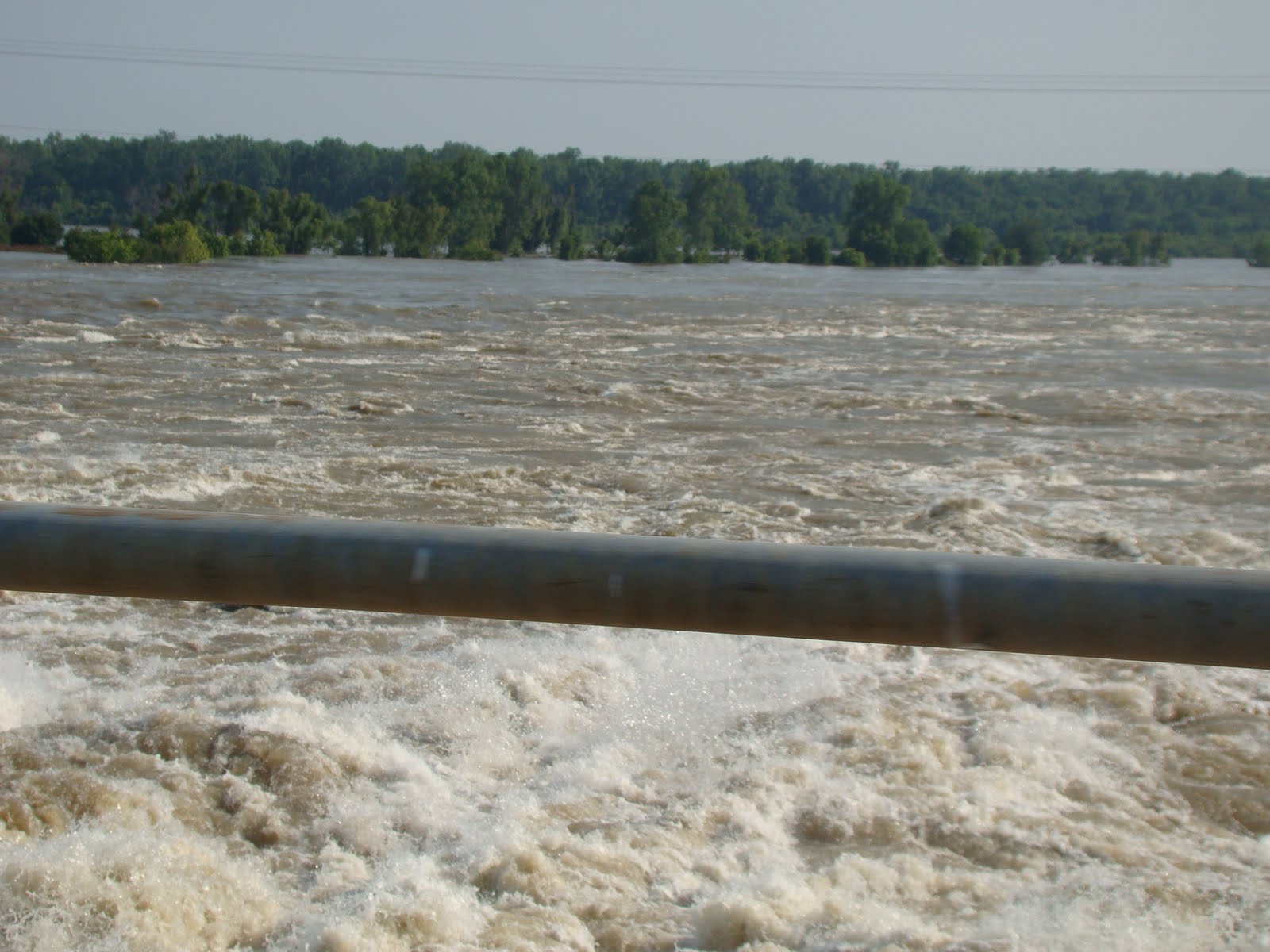
After we ate we started to see what the mighty Mississippi was up to and what the Marganza Levee was doing to the area. Almost all of the water that you see is normally dry ground and the road that we are on actually works as another Levee. You can see that many of the deer were stranded between the flood waters and a 12 foot fence that they could not get over. If they could have, there was no where for them to go. They were on our left and on the right side of us was more water. But with the exception of no where to hide they were alright. They had all they needed to drink and eat as they were stranded in a soy bean field. I will start part 3 tomorrow which will be the tornado disaster areas, Mississippi and Alabama. At the end of this Blog is some information that I researched about the Morganza Spillway, I hope you enjoy reading it.


The Morganza Spillway, between the Mississippi River and the Atchafalaya Basin, shown while open in 1973. Water flows from the Mississippi (upper right) into the Morganza Floodway (lower left).
The Morganza Spillway is a flood-control structure in the U.S. state of Louisiana along the western bank of the Mississippi River at river mile 280, near Morganza in Pointe Coupee Parish. The spillway stands between the Mississippi and the Morganza Floodway, which leads to the Atchafalaya Basin and the Atchafalaya River in south-central Louisiana. Its purpose is to divert water from the Mississippi River during major flood events by flooding the Atchafalaya Basin, including the Atchafalaya River and the Atchafalaya Swamp. The spillway and adjacent levees also help prevent the Mississippi from changing its course through the major port cities of Baton Rouge and New Orleans, Louisiana, to a new course down the Atchafalaya River to the Gulf of Mexico. The Morganza Spillway, operated by the U.S. Army Corps of Engineers, was opened during the 1973 and 2011 Mississippi River floods.[1][2][3][4][5]
The Great Mississippi Flood of 1927 was the most destructive river flood in the history of the United States,[6] in large part due to the Mississippi River swelling to 80 miles wide in spots.[7] To prevent a repeat of the Great Flood of 1927, and better control river flooding in general, Congress passed the Flood Control Act of 1928 to authorize the United States Army Corps of Engineers to build the Bonnet Carre Spillway (located 33 miles above New Orleans and completed in 1931),[8] the Birds Point floodway in Missouri, and the Morganza Floodway as part of the 1928 Mississippi River and Tributaries Project.[7] The Morganza control structure portion of the project was completed in 1954[7] and subsequently became incorporated into the Mississippi River Commission's 1956 project design flood,[9] which added the Old River Control Structure in 1963 to the protections used to prevent Mississippi River flood.[10] The Flood Control Act of 1965 provided further regulation over the Morganza Spillway's role in Mississippi River flood prevention. A concrete pit called a stilling basin was added at the Morganza Spillway in 1977 "to provide erosion protection after the velocity of water pouring through the open bays during a 1973 flood caused severe scouring of the land behind the bays."[11]
One of the 125 gates on the tail bay side of the Morganza Floodway.
The Morganza Spillway, a 3,900-foot (1,200 m) controlled spillway using a set of flood gates to control the volume of water entering the Morganza Floodway from the Mississippi River, consists of a concrete weir, two sluice gates, seventeen scour indicators, and 125 gated openings which can allow up to 600,000 cubic feet per second (17,000 m3/s) of water to be diverted from the Mississippi River into the Atchafalaya Basin during major floods. The project was completed in 1954.
A highway (Louisiana Route 1) and the Kansas City Southern Railway cross the structure.
The Corps of Engineers maintains the structures and, in times of flood, monitors their piers for scouring and stability. To lift and lower the flood gates, the Corps of Engineers maneuvers a movable crane along the spillway to the particular opening.
Operation during floods
The land on both sides of the Morganza Spillway is above normal river water levels, and usually dry. In order for water to reach the spillway, the Mississippi must first rise well above its flood stage, overtopping its banks. The Corps of Engineers considers opening the Morganza Spillway when the flow of the Mississippi at Red River Landing, Louisiana,[12][13] is greater than 1,500,000 cu ft/s (42,000 m3/s) and rising.[1]
Flow capacity for the Mississippi river in thousands of cubic feet per second.[14]
Water from the Mississippi is normally diverted into the Atchafalaya Basin at only one place, the Old River Control Structure (ORCS), in use since 1963, where floodgates are routinely used to redirect the Mississippi's flow into the Atchafalaya River such that the volume of the two rivers is split 70%/30%, respectively, as measured at the latitude of Red River Landing. During the 1973 Mississippi flood, the ORCS was being damaged due to high flow rates, leading to the opening of the Morganza Spillway to help relieve this pressure. Subsequently, the nearby Old River Control Auxiliary Structure (ORCAS) was constructed, adding additional floodgates for use during major floods.
The Morganza Spillway, about 30 miles downriver from ORCS and ORCAS, is designed for emergency use to divert additional water from the Mississippi River into the Morganza floodway, which merges downstream with the Atchafalaya floodway before entering the Gulf. Diversion of water from the Mississippi's main channel has the effect of lowering water level in the Mississippi downstream of the spillway, helping to relieve stress on levees and other flood control structures both upstream and down. Besides controlling flooding in a given event, the system is also designed to prevent the Mississippi River from permanently altering course down the Atchafalaya River, bypassing Baton Rouge and New Orleans.[1][2][3][4]
Water that passes the Morganza Spillway first enters the Morganza Floodway, which extends from the spillway at the Mississippi River south to the East Atchafalaya River levee. The floodway, 20 miles (32 km) long and 5 miles (8.0 km) wide, includes a stilling basin, an approach channel, an outlet channel, and two guide levees.[1] From there, diverted water enters the Atchafalaya River Basin Floodway near Krotz Springs, Louisiana,[1] and continues to the Gulf of Mexico.
In an extreme flood event, a major release of water from the Morganza Spillway into the Morganza Floodway and Atchafalaya Basin inundates not only the floodways themselves (between their levees), but extensive additional areas of southern Louisiana throughout the Atchafalaya Basin. In such an event, the water level of the Mississippi, high enough to overtop the Spillway, would already be flooding some areas in the Basin downstream of the spillway, due to increased flow through the Old River Control Structure and the Old River Control Auxiliary Structure, as well as possible overtopping of levees near the spillway.[15] This flooding, plus any additional water from a Morganza Spillway release, together determine the total extent of flooding throughout the Atchafalaya Basin during a major Mississippi River flood.
At risk in the Atchafalaya Basin are Morgan City (population 13,500), various smaller populated places, many farms, thousands of oil and gas wells, and considerable swampland. Inhabitants know that the region is a natural floodplain, and the Corps of Engineers issues written notices annually to all interests reminding them of the possibility that it might open the spillway and flood the area. Any decision to open the spillway must be carefully planned to give ample warning and protect life and property. Part of that planning process includes the Corps' preparation of maps known as "inundation scenarios" so that interested parties can discuss how much water, if any, should be allowed through the spillway.[1][16][17][18][19][20][21][22] [23]
During both moderate and severe floods of the Mississippi, the Bonnet Carré Spillway can also be opened to help protect New Orleans, many parts of which are below sea level. The Bonnet Carré Spillway, built after the Great Mississippi Flood of 1927, is located well downstream of Morganza, where the Mississippi River approaches Lake Pontchartrain near New Orleans. The Corps uses Bonnet Carré to divert floodwaters into the lake in order to protect the levees near New Orleans.
Integrity of the Morganza Spillway, the Old River Control Structure, and nearby levees is essential to prevent the Mississippi from diverting its main channel into the Atchafalaya Basin; see "Risk of major course change in the Lower Mississippi River" for further discussion.
Have a Blessed day and I hope you enjoyed this portion of our vacation, stay tuned for part 3.
“For the Lord himself will come down from heaven, with a loud command, with the voice of the archangel and with the trumpet call of God, and the dead in Christ will rise first. After that, we who are still alive and are left will be caught up together with them in the clouds to meet the Lord in the air. And so we will be with the Lord forever.” -1 Thessalonians 4:16-17
Comments
Post a Comment